
Land Intelligence for
Energy & Utilities
Land Intelligence for Energy & Utilities
Simplify land rights management, infrastructure planning, and regulatory compliance with Whitestar’s land grids and parcel data. Trusted by Energy & Utilities and other highly regulated industries, our GIS-ready data delivers consistent, decision-grade land intelligence beyond parcel data alone.
Why Energy & Utilities Companies
Choose Whitestar

Decision-Grade Accuracy
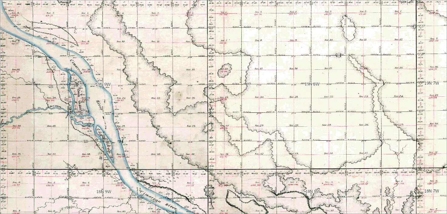
We deliver legally defensible land boundaries that compiled parcel data alone cannot consistently provide. TrueGRID™ is built from original General Land Office (GLO) survey plats—including Lots, Tracts, and Quarter-Quarter divisions.

Regulatory & Audit Confidence
We support ROW, pipeline, transmission, and permitting workflows with land data designed to withstand regulatory review, audits, and disputes, reducing compliance risk and costly rework.

GIS & AI‑Ready Metadata at Scale
We provide fully standardized nationwide land data that enables repeatable analytics and automation using Python, FME, and enterprise GIS environments including ArcGIS, without county-by-county rework or compliance gaps.
Whitestar is an Esri Gold Partner, ensuring our land grids and parcel data align with enterprise ArcGIS standards. From ArcGIS Pro to ArcGIS Enterprise, TrueGRID™ integrates cleanly into existing GIS environments—reducing friction, rework, and data normalization overhead.
Built for Esri and Enterprise GIS Environments
Whitestar is an Esri Gold Partner, ensuring our land grids and parcel data align with enterprise ArcGIS standards. From ArcGIS Pro to ArcGIS Enterprise, TrueGRID integrates cleanly into existing GIS environments—reducing friction, rework, and data normalization overhead.

Compiled parcel datasets vary by county, lack legal defensibility, and introduce uncertainty into regulated workflows and provide only partial or inconsistent visibility into land rights. Whitestar’s land grids provide the complete picture, giving Energy & Utilities teams consistent, auditable, decision-grade land intelligence they can rely on.
Most Parcel Data Isn’t Built for
High-Stakes Land Decisions
Compiled parcel datasets vary by county, lack legal defensibility, and introduce uncertainty into regulated workflows and provide only partial or inconsistent visibility into land rights. Whitestar’s land grids provide the complete picture, giving Energy & Utilities teams consistent, auditable, decision-grade land intelligence they can rely on.
Built for Regulated Industries
Where Accuracy Isn’t Optional
Energy & Utilities organizations operate in some of the most regulated environments in the world. Whitestar delivers enterprise-grade land intelligence that is legally defensible, operationally reliable, and built to scale across infrastructure-driven, highly regulated industries.
Energy & Utilities
Transmission,
distribution, ROW
Oil & Gas
Pipeline and
midstream operations
Forestry &
Natural Resources
Transmission,
distribution, ROW
Renewable Energy
Siting, interconnection,
land rights
Mining
Pipeline and
midstream operations
Telecommunications
Network expansion
and corridors
Transportation
Siting, interconnection,
land rights
Frequently Asked Questions
-
Parcel data is typically compiled for reference and taxation purposes. Whitestar’s land grids are constructed from authoritative documents, delivering decision-grade accuracy for regulated land workflows.
-
Yes. Whitestar is trusted by Energy & Utilities and other highly regulated industries that require land data for infrastructure planning, ROW management, and regulatory compliance.
-
TrueGRID™ is designed to support regulated decisions, providing consistent, traceable land data that reduces risk during permitting, audits, and dispute resolution.
-
Whitestar’s land grids are built to integrate with parcel data and enterprise GIS workflows, giving regulated organizations both context and consistency at scale.
Most parcel datasets are compiled. Whitestar’s land grids are constructed. Gain accuracy, regulatory confidence, and AI-ready GIS data today.
Go Beyond Parcel Data with Whitestar
Most parcel datasets are compiled.
Whitestar’s land grids are constructed. Gain accuracy, regulatory confidence, and AI-ready GIS data today.