
Digitize Proprietary and Competitive Land Data
Convert Legal Descriptions into GIS-Ready Land Intelligence. Paper to Poly turns deeds, leases, easements, right of way, and legacy agreements into precise, GIS-Ready polygons at enterprise scale.
Turn Legacy Land Records into AI Ready Land Intelligence

Using proprietary OCR, NLP, and machine learning mapped against Whitestar’s national land grid and parcel data, Paper to Poly eliminates manual digitizing and delivers defensible geospatial data energy and infrastructure teams can trust.
AI + Human Verification · Built for Large Land Portfolios · ArcGIS-Ready
What Is Paper to Poly?
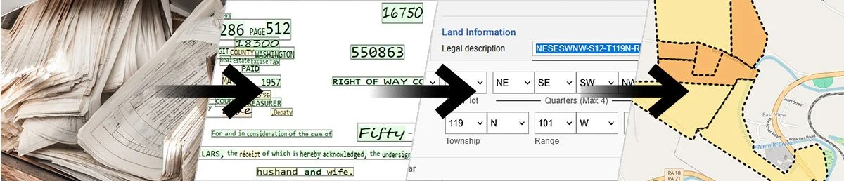
Paper to Poly is a legal-description-to-polygon conversion service designed for organizations managing large, regulated land portfolios.
It extracts metes-and-bounds, aliquot parts, and survey descriptions from deeds, leases, easements, right of way, and agreements—then converts them into accurate, standards-based GIS polygons that integrate directly with ArcGIS and enterprise systems.
The result is faster mapping, fewer errors, and land data that supports real operational and regulatory decisions.
How Paper to Poly Works
Paper to Poly replaces manual legal description mapping with a scalable, defensible workflow.
-
OCR and NLP extract metes-and-bounds, aliquot parts, and survey references from analog and digital documents.
-
Descriptions are normalized and aligned to Whitestar’s authoritative national land grid, parcel data, and reference frameworks.
-
Land and geospatial experts perform QA/QC to ensure accuracy.
-
GIS-ready polygons are created with consistent geometry and attribution.
-
Outputs integrate seamlessly with ArcGIS and enterprise mapping workflows.

Why Land Data Becomes a Project Bottleneck
For energy, utility, and midstream organizations, land records rarely arrive GIS ready. Legal descriptions are buried across deeds, leases, easements, rights of way, and legacy agreements—written in inconsistent formats and terminology that make manual mapping time-consuming and error-prone. The result is a bottleneck for due diligence, permitting, and compliance.
Scale Land Operations Without Scaling Headcount
By eliminating manual legal description mapping, organizations unlock faster project timelines, lower risk, and the ability to scale land operations.
-
Convet weeks of manual legal mapping into days without sacrificing accuracy.
-
We free GIS teams from hand-digitizing so they can focus on analysis, planning, and insight.
-
Standardized polygons reduce interpretation risk across large land portfolios.
-
Process hundreds, thousands, or millions of legal descriptions consistently.
-
Deploy without custom formats or re-engineering existing workflows.
Transform Land Data Operations Across the Enterprise
Automated legal description mapping enables faster execution, reduced risk, and consistent land intelligence across teams and portfolios.
GIS Managers & Analysts
Eliminate manual mapping bottlenecks and enforce consistent geometry at scale.
Operations & Planning
Plan routing, expansion, and assets using accurate, spatially reliable land data.
Land & ROW Teams
Gain faster visibility into land position and spatial coverage across portfolios.
Compliance & Regulatory Teams
Rely on consistent, defensible land boundaries during audits and regulatory reviews.
IT & Data Leaders
Scale land data processing without adding headcount or introducing custom tools.

Trusted Across Large, Complex Land Portfolios
Frequently Asked Questions
-
Metes and bounds, aliquot parts, lots, tracts, survey-based descriptions, and hybrid formats.
-
Paper to Poly is delivered as a managed service designed to scale across large portfolios.
-
Paper to Poly leverages Whitestar’s authoritative land grid and standardized interpretation methods to ensure consistent, defensible results.
-
No. Paper to Poly removes manual mapping work so your GIS team can focus on higher-value analysis and planning.
One of our team members will connect with you to digitize a sample of your analog legal land descriptions for free.
Welcome to the Paper to Polygon Revolution
Most parcel datasets are compiled.
Whitestar’s land grids are constructed. Gain accuracy, regulatory confidence, and AI-ready GIS data today.